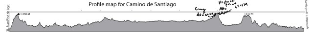
I love maps, and have been studying quite a few in preparation for my upcoming Camino. The above pretty much covers the ups and downs of those 500 miles, though all scrunched up so half a thousand miles will fit on the page. To give some perspective, the highest point on the trek falls at about the 2/3 mark of the journey with a double peak, one called Cruz de Ferro marked, as the name says, by a simple iron cross. This sits at 4,934 feet. The other twin of the two peaks is Altar Mayor at 4,970 feet. By the time I reach this highest reach of the walk, I will either be exhausted, or invigorated, more likely both.
 But the very beginning of the so-called French Way will present an immediate challenge as the trail begins at around 656 feet, about the elevation of San Antonio, but then climbs over the first 12.5 miles to 4757 feet. Apparently, the weather can become quite variable, with rain, fog, and high winds presenting potential challenges. Should be interesting, to say the least. Santiago de Compostela or bust!
Frankly, I’m surprised my brother Kenneth and especially my sister Brenda have not suggested I skip that first leg of my journey. Years ago I became somewhat famously “lost” along the Continental Divide Trail, just below Colorado’s Monarch Pass. I had persuaded them to drop me off at the next pass south, Marshall Pass. I planned to hike and jog the 11 miles from Marshall to Monarch, this all at an elevation ranging from 10,834 to 11,970. I got a late start, then got lost when I got into snow up to mid-calf. Needless to say, neither Brenda nor Kenneth were too happy about my (mis)adventure but, hey, I lived to tell about it. Hopefully, I’ll be able to say the same about the 500 mile Camino de Santiago trek.
